 Filter: Categories of Wisconsin Historical Images
Filter: FORMAT_DIMENSIONS of 28 x 22 cm.
Filter: Categories of Wisconsin Historical Images
Filter: FORMAT_DIMENSIONS of 28 x 22 cm.

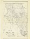
| Date: | 1923 |
|---|---|
| Description: | A hand-colored map of Marinette County, Wisconsin that shows, townships, towns and plot sections, lakes and streams, cities and villages, and rail lines an... |

| Date: | 1949 |
|---|---|
| Description: | This 1949 map shows the topography and significant landmarks in Copper Falls State Park, Ashland County, Wisconsin. |

| Date: | 1877 |
|---|---|
| Description: | Relief shown by hachures. Shows land ownership by name, wards, railroads, mills, dams, city limits, Chippewa River, and Half Moon Lake. Includes index of m... |

| Date: | 1877 |
|---|---|
| Description: | Relief shown by hachures. Shows land ownership by name, wards, railroads, mills, dams, city limits, Chippewa River, and Half Moon Lake. Includes index of m... |

| Date: | 1889 |
|---|---|
| Description: | Shows city limits, railroads, mills, schools, cemeteries, dams, parks, lumber yards, log canals, log reservoir, Chippewa River, Eau Claire River, and Half ... |
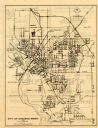
| Date: | 1971 |
|---|---|
| Description: | This map of Stevens Point shows labeled streets and selected points of interest: "Holiday Inn," "Westernberger's Gifts," "Ralph L. Banke MLS Realtor," "Gol... |

| Date: | 1940 |
|---|---|
| Description: | This map of Aztalan is pencil and ink on paper. The map shows streets, local businesses, churches, houses, and the Crawfish River. The map reads: "Informat... |
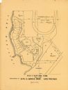
| Date: | 1900 |
|---|---|
| Description: | This maps shows part of Galesville, Trempealeau County, Wisconsin. The map shows lots for sale, local streets, and part of Lake Marinuka. Lots are numbered... |

| Date: | 1960 |
|---|---|
| Description: | This blue print map shows village limits, collector residential streets, and primary residential streets. The upper right corner features a key to street t... |

| Date: | 1902 |
|---|---|
| Description: | This map shows shoals near Waugoshance Point. Lighthouses are labeled. Depths are shown by soundings and tints. Relief is shown by hachures. Inset includes... |

| Date: | 1853 |
|---|---|
| Description: | This facsimile map shows counties, towns, and waterways in the state of Wisconsin. Included are portions of Iowa, Michigan, and Minnesota. Lake Superior an... |

| Date: | 1921 |
|---|---|
| Description: | This map, oriented with north to the upper right, shows roads, railroads, and points of interest. Lake Mendota, Wingra, Monona, Waubesa, Mud, Hook, Island,... |
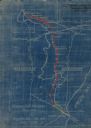
| Date: | 1949 |
|---|---|
| Description: | This map is comprised of six plates that depict the rout the Sauks and Meskwakis, led by Black Hawk, took through Wisconsin during the Black Hawk War of 18... |
| Date: | 1923 |
|---|---|
| Description: | This blueprint map shows Wisconsin and Michigan-owned railroad and trackage rights from Iron Mountain to Menominee, Michigan, as well as other railroads. W... |

| Date: | 1944 |
|---|---|
| Description: | This pictorial map shows points of general and historical interest in Ozaukee County. Original caption reads: "Ozaukee county is the "biggest little county... |

| Date: | 1982 |
|---|---|
| Description: | This map shows the location of major settlement regions for various ethnic groups. Includes a legend in lower left hand corner. Sparse settlement is repres... |
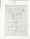
| Date: | 1959 |
|---|---|
| Description: | This map shows roads, landowners, acreages, and buildings. |
If you didn't find the material you searched for, our Library Reference Staff can help.
Call our reference desk at 608-264-6535 or email us at: